 | ||
| Topographic 3D model : Dallol domes | ||
This 3D model was performed by Agisoft Metashape Professional Edition software (Educational License). Digital images were taken by Olivier Grunwald, french photographer. This work is part of Erasmus+ Key Action 2 2017-1-UK01-KA203- 036719 '3DTeLC – Bringing the 3D-world into the classroom: a new approach to Teaching, Learning and Communicating the science of geohazards in terrestrial and marine environments'. The generated OBJ tiled model was tested on GeaVR and VRVolc Virtual Reality softwares (See links below). | 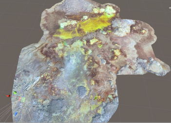 | |
| Downloads and links | ||
| Data | Dallol_Dome_03222020.zip | |
| | DataCite - XML - JSON | |
| Interoperable | https://catalog.opgc.uca.fr/geonetwork2/srv/eng/catalog.search#/metadata/d8a9a28d-9bf0-4889-8a0e-8c4e63a7942d | |
| Links | https://www.geavr.eu/ https://doi.org/10.25519/VRVOLC http://www.opgc.fr/vobs/3DTeLC/VRgeomorph-Dallol_dome/ https://www.oliviergrunewald.com/ | |
| DOI | https://doi.org/10.25519/TXZC-1724 DOI | |
About this resource | ||
| Keywords | Geology, Elevation, Volcanology, Topography, 3D model, Dallol, Dataset | |
Ressource Type | Dataset | |
| License | Creative Commons Attribution 4.0 International | |
Funding references | ||
| Creators | Emmanuel DELAGE, Olivier Grunwald, Benjamin van Wyk de Vries | |
Creation date | 2020-03-22 | |
| Publisher | OPGC | |
Publication year | 2023 | |
Technical information | ||
Spatial extent | ||
| Formats | OBJ | |
| Software | ||
| Lineage | ||