 | ||
| Precipitation accumulation and biases for two cases observed over France in 2022 | ||
The purpose of the MAPS project is to evaluate 11 satellite products (GHE, PDIR, IMERG-Early v6, IMERG-Late v6, CMORPH v0.x, CMORPH-RT v0.x, GSMaP-NRT v7, GSMaP-NRT-GC v7, GSMaP-NOW v7, GSMaP-NOW-GC v7, and DATABOURG) currently available and compare them to 2 ground-based radar networks (PANTHERE and OPERA) and the French rain-gauge network RADOME. Two case studies of intense precipitation over France (22 to 25 April 2022 and 24 to 29 June 2022) were selected. This DOI contains a Python source code (ACCSUM.py) allowing to: - Present the study areas, - Visualise the precipitation amounts at the end of each case study, - Compute the absolute bias with the point-to-pixel method at the point of the stations, - Intercompare the bias values between the two radar products, - Visualise the synoptic conditions from ECMWF ERA5 data, - Represent the radar coverage over the country and the recovery areas of both radar products over 3h periods. This version does not contain PANTHERE dataset. The complete dataset, including PANTHERE, is available on request. | 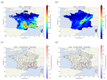 | |
| Downloads and links | ||
| Data | Data_Code_Causse_et_al_2023.zip | |
| | DataCite - XML - JSON | |
| Interoperable | https://catalog.opgc.uca.fr/geonetwork2/srv/eng/catalog.search#/metadata/d9e49fdd-6da0-4325-bdc0-aa3242a1b89b | |
| Links | https://www.mdpi.com/2073-4433/14/12/1726 | |
| DOI | https://doi.org/10.25519/YTHE-0C73 DOI | |
About this resource | ||
| Keywords | Meteorological geographical features, precipitation, remote sensing, radars, satellite, Dataset | |
Ressource Type | Dataset | |
| License | Creative Commons Attribution 4.0 International | |
Funding references | ||
| Creators | Antoine Causse, Celine Planche, Emmanuel Buisson, Jean-Luc Baray | |
Creation date | 2023-12-04 | |
| Publisher | OPGC, LaMP | |
Publication year | 2023 | |
Technical information | ||
Spatial extent | ||
| Formats | Parquet, Python 3, JPG | |
| Software | ||
| Lineage | ||