 |  | |
| Comparison of M10 and M20 Meteomodem radiosondes relative humidity measurements with ECMWF ERA5 above France : focus on the upper troposphere | ||
BECOM (Better Contrail Mitigation) is a project proposing to develop strategies to mitigate the formation and impact of contrails. By combining advanced atmospheric modelling with real-world flight data, it aims to identify optimal flight paths and operational practices that minimize contrail formation (https://becom-project.eu/). We documented the differences between radiosonde relative humidity measurements and ERA5 reanalysis over France. This study is part of the work package Operational and new measurements and characterization of the project BECOM. This DOI provides access to the dataset used for the radiosonde–ERA5 relative humidity comparison. | 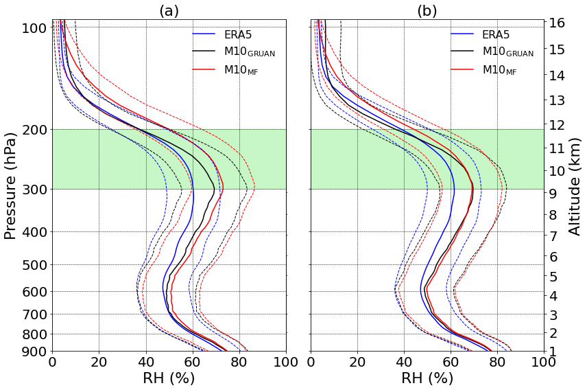 | |
| Downloads and links | ||
| Data | BECOM_Diarra_Dataset_202601.zip | |
| | DataCite - XML - JSON | |
| Links | https://becom-project.eu/ | |
| DOI | https://www.opgc.fr/DOI/10.25519/he28-c712/ DOI | |
About this resource | ||
| Keywords | Relative humidity, Radiosondes, ERA5, GRUAN, Upper troposphere | |
Ressource Type | Dataset | |
| License | Creative Commons Attribution 4.0 International | |
Funding references | The project BECOM has received funding from the Horizon Europe research and innovation actions program under grant agreement 101056885. CO-PDD is an instrumented site of OPGC observatory and LaMP laboratory, supported by Université Clermont Auvergne (UCA), Centre National de la Recherche Scientifique (CNRS-INSU) and Centre National d'Etudes Spatiales (CNES). | |
| Creators | Sidy Diarra, Nadège Montoux, Jean-Luc Baray, Jean-Charles Dupont, Antoine Farah, Dunya Alraddawi, Philippe Keckhut | |
Creation date | July 2023 | |
| Publisher | OPGC, LaMP | |
Publication year | 2026 | |
Technical information | ||
Spatial extent | Nîmes : latitude = 43.87°, longitude = 4.40° Trappes : latitude = 48.77°, longitude = 2.01° | |
| Formats | CSV, Python | |
| Software | Python code is included for reading and plotting data | |
| Lineage | ||