 | ||
| Self Potential database on the Chaîne des Puys | ||
This dataset was created from self potential data acquired over a period of time between 1989 and 2022. The data acquired on the Volvic watershed were first used in a DIREN report (Labazuy, 2000) and in the thesis of Joux (2002). This dataset has been largely completed in the framework of the CAPRICE project (Aumar, 2022) on the Come and Veyre watersheds. | 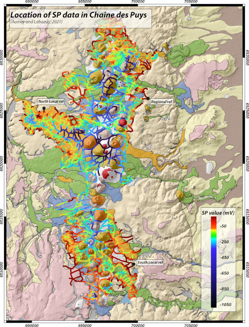 | |
| Downloads and links | ||
| Data | Carte_PS_DOI.tif Self Potential dataset of the Chaine des Puys.zip | |
| | DataCite - XML - JSON | |
| Interoperable | https://catalog.opgc.uca.fr/geonetwork2/srv/eng/catalog.search#/metadata/864924be-6925-4643-9337-96fc04c1a3b2 | |
| DOI | https://doi.org/10.1016/j.dib.2023.109533 Data Article https://doi.org/10.25519/R1PR-G644 Prevolcanic topography and hydrogeological watershed of the Chaîne des Puys https://doi.org/10.25519/ZGHC-N543 DOI | |
About this resource | ||
| Keywords | Geology, Self-Potential, hydrogeophysics, Chaîne des Puys, Volcanics aquifers, CAPRICE project, Dataset | |
Ressource Type | Dataset | |
| License | Creative Commons Attribution 4.0 International | |
Funding references | ||
| Creators | Cyril Aumar, Philippe Labazuy | |
Creation date | 2022-04-15 | |
| Publisher | OPGC, LMV | |
Publication year | 2021 | |
Technical information | ||
Spatial extent | ||
| Formats | CSV, ESRI_shape, XLSX | |
| Software | ||
| Lineage | ||